
UPDATE: The 2012 Sonar Training Workshop was a great success! Class participants not only learned the basics of deploying and using the sonar in the field, of crunching data and manipulating and mosaicking sonar imagery, but they actually discovered a new archaeological site in the form of an old 19th century anchor! If you are interested in this training experience, contact us and let us know, we can arrange customized dates to fit your schedule.
Sonar Training Workshop (July 15-20 2012)
This class will indoctrinate the student on the basic principles of archaeological underwater survey using sidescan sonar technology. Through the one-week course, a series of classroom and field experiences will demonstrate and directly involve students in the procedures of establishing a survey plan and enacting it. After learning how to gather data, then collecting it, students will learn how to mosaic sidescan imagery and create a deliverable product used for analysis and presentation. By the end of the course, each student will have operated a sidescan sonar, used it to identify underwater features, and helped compile an acoustic survey report.
What is a Sidescan Sonar?
A sidescan sonar broadcasts a specific frequency acoustic signal, or signals, to fill the water around it with sound energy. These sound waves bounce off the sea floor, or other items such as fish, rock ledges, wrecks, etc. and return to the sidescan unit where the returned signal is transformed into an image of the bottom. Simply, the sonar paints a swath of the sea floor and turns it into a picture. Scientists, surveyors, and defense specialists use sidescan sonars frequently to survey river, harbor, lake, pond, and other diverse types of water bodies to look for changes, threats, shipwrecks, or geological features. Sidescan has hundreds of applications and the focus of this course, while largely archaeological, is relevant to many other fields. Modern sonography is in use throughout the world and is expanding our understanding of the earth’s final frontier, the planet’s oceans.
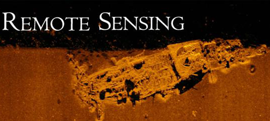
What is Remote Sensing and Where Does the Sidescan Sonar Fit In?
Remote sensing is often the first stage of maritime research in the field. After historic documentation and research has isolated areas of interest, places defined that might be impacted by growth and development, or simply an inventory is needed, survey is the first field operation that sheds light on underwater history. Of remote sensing gear, the sidescan sonar is one of the most commonly used pieces of equipment and is often found alongside marine magnetometers and subbottom profilers. Sidescan, however, continues to be useful to monitor changes or developments and creates a visual record for further analysis. Sites which have been affected by nature (storms, natural decay, currents, etc.) or changed by human impact (dredging, anchoring, trawling, etc.) can benefit from continued monitoring with sonar. Sidescan can be deployed in conditions and to depths at which human divers would be unduly subjected to dangerous conditions and generates a record for topside analysts to view with real-time speed and precision.
What Do I Need to Know For This Class?
While archaeological experience is helpful, it is not required. Students may simply wish to experience sidescan sonography as an introduction to maritime survey or hydrographic study. This course places students into a hands-on environment where they can learn, all while having instructors on-hand to help and guide the process.
What Else Do Students Learn?
No sidescan sonar is complete without the software to operate it, GPS to orient it, and a vessel to support it. All of these systems are integral in this class and students will have direct experience with SonarPro and SonarWIZ 5.0 software, Trimble DGPS products, and Klein 3900 Search and Recovery sonar hardware. While a boat captain is provided, each student will operate the sonar from the helm and the topside control unit to gain full-spectrum understanding of sonar field operation.
The Course Includes:
-Classroom Lectures
-Equipment Setup and Usage
-Basic Operation and Troubleshooting
-Software Use
-Course Packet
-Vessel Time
-Housing (dormitory-style)
*Participants will need to bring their own toiletries, bedding, lunch, and transportation to St. Augustine and from the Field House to the Lighthouse Museum.
Online Application Forms and Fees
The fee for the workshop is $1,350. A $250 deposit is due upon acceptance and the remainder is due on the first day of class. If you sign up for two or more of our classes (Field School, Conservation Workshop, Sonar Training Workshop), special discounts apply as listed below, and a $250 deposit is due for the first class with only an additional $100 is due for each additional class. All fees are payable to LAMP. The deposit and remaining balance may be paid with check or credit card.
Pricing Starting from $650.00
Full Fee: $1,350.00
Sign up by March 30th, 2012, deduct $100.00
LAMP Conservation Workshop students deduct $100.00
LAMP 2012 Field School students, deduct $200.00
Students taking both the 2012 Field School and Conservation Workshop deduct $300.00 from combined fees (Field School + Conservation Workshop)
For students providing their own housing, deduct an additional $300.00 from single course fee.
Special scheduling available on request. Contact us if you are interested in setting up your own class!